
Overview
Through major changes to the number 2 bus route along the A37 and A4018, we are aiming to make bus journey times quicker and more reliable.
The project also sets out to make it easier and more pleasant to walk, wheel and cycle by improving public spaces and making the route more accessible for all road users.
Our aim is to provide a better travelling experience for people who travel actively or by public transport, to encourage more people to choose to make the switch over to sustainable transport, which will help reduce congestion and improve air quality.
It is all part of plans to transform Bristol’s road network, introducing quicker and more reliable bus travel, cleaner air, and improved active travel routes.
About
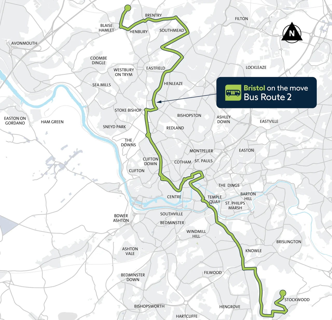
The project sets out to improve the 13-mile stretch of the number 2 bus route that travels through Bristol on the A37 to A4018, from Henbury in the north to Stockwood in the south of the city.
The aim is to:
- Make the number 2 bus service faster and more reliable and benefit other buses that use parts of this route
- Create quieter, cleaner, greener and safer roads
- Boost the number of people who walk, wheel, cycle and catch the bus
- Support and revitalise high streets by creating attractive public spaces where people want to stop and spend time
- Connect people to jobs, education, services and one another
- Improve local air quality and reduce CO2 emissions from transport
Main plans are
- New bus lanes and bus prioritisation at traffic signals
- A network of joined up separated cycleways
- Improving public spaces with new paving, planting, trees and seating
- Making the route more accessible for pedestrians
- Upgrading bus stops and bus shelters
- Adding delivery bays and disabled parking bays
Early plans for north section of the route
- Installing dropped kerbs and tactile paving at side roads to make it easier to cross the road
- Improving pedestrian crossings at mini roundabouts
- Narrowing the width of some side roads that are unnecessarily wide
Plans for central section of the route
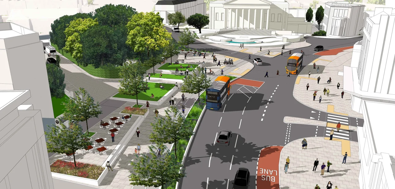
Our plans for the route from Queens Road to College Green via the Triangle and Park Street include reducing Queens Road to one lane for general traffic in both directions from Whiteladies Road to the Triangle.
Main changes also include adding a bus gate at the top of Park Street and a bus lane at the College Green and Canons Road junction. General traffic would still be able to drive onto Park Street via St George’s Road and exit in the normal way.
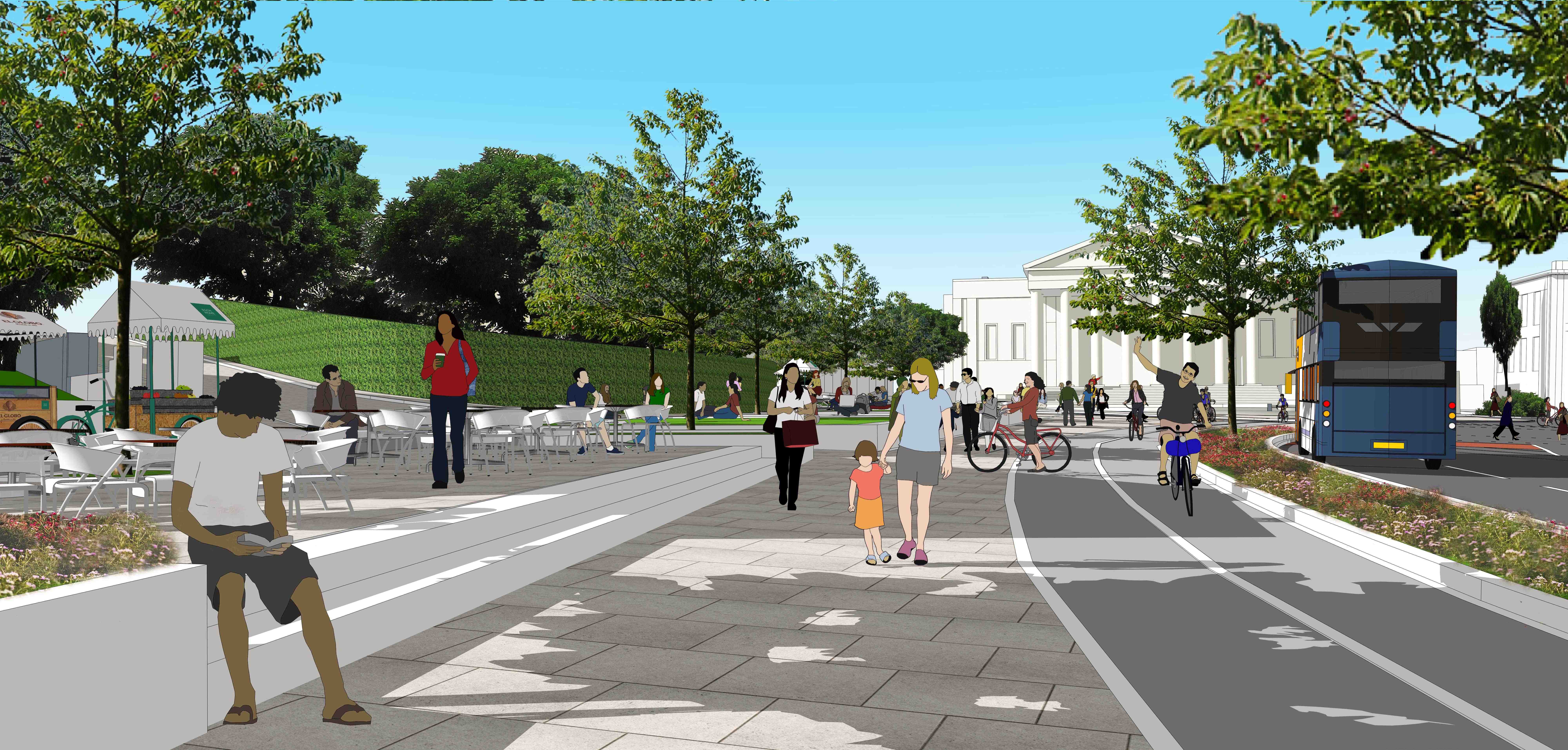
Other changes include adding large areas of green public space, separated cycle paths, upgrading bus stops and widening pavements and improving crossings.
Queens Road plans
- Reducing Queens Road to one lane for general traffic in both directions from Whiteladies Road to the Triangle, to make way for a new public green space in front of the Victoria Rooms.
- New three-stage traffic lights at Queens Road’s junction with Whiteladies Road.
- Closing Richmond Hill and Park Place to through traffic where they meet Queens Road.
- A new separated cycle path from Whiteladies Road along Queens Road and extra sections of separated cycle path at the entrance to Richmond Hill and Park Place.
- Adding an inbound bus lane from Whiteladies Road that continues to the Queens Road/Triangle bus stops.
- Installing an island on the zebra crossing and a bus shelter to the bus stop on Queens Avenue.
- Adding two passing places on Richmond Hill and removing the build outs at Richmond Hill and Frederick Place to allow for two-way traffic.
- Adding seating areas, new trees and landscaping to the new public green space on Queens Road.
- Moving the Boer War Memorial into the new public space. The fountain and Edward VII statue in front of the Victoria Rooms will not be moved.
Triangle plans
- A section of bus lane from University Road to provide priority access to Park Street, while retaining the straight ahead lane to direct general traffic along Park Row.
- Closing Berkeley Avenue to general traffic and making the existing University Road closure to through traffic permanent.
- Moving the outbound bus stops from Queens Road to Triangle South to make space for a cycle path and loading bay.
- Removing parking on Queens Road/Triangle to allow for a separated cycle path.
- New disabled parking bays, loading bays and taxi ranks.
- Adding an inbound bus lane from Whiteladies Road that continues to the Queens Road/Triangle bus stops.
- Adding a separated cycle path going in the direction of traffic on the north side of Queens Road (outside Wills Memorial Building) with a stepped track cycle path going with the direction of traffic on the south side of the Triangle (outside Wetherspoons).
- Moving the loading bay outside Wetherspoons so it is between the pavement and cycle path.
- Cycle and e-scooter parking.
Park Street plans
- A bus gate at the top of Park Street, approached by a bus lane from Queens Road, to prevent through traffic. This would work in combination with a bus lane on the College Green and Canons Road junction, which would feed general traffic onto Anchor Road. The bus gate and bus lanes would allow access for buses, taxis, motorcycles, and cycles only. Traffic visiting Park Street and local traffic would still be able to access Park Street but only from St Georges Road. Traffic would exit Park Street and College Green as normal.
- Widening the pavement on the east side of Park Street to provide an improved pedestrian environment as well as opportunities for seating and planters.
- Reversing the one-way direction on Park Street Avenue to include time restricted loading to allow the space to be used in the afternoon/evenings for pedestrian activities.
- Moving parking to the west side of the street to make it safer to cycle down Park Street.
- Adding cycle and e-scooter parking laybys.
- Adding a build out at the St Georges Road junction.
- Making Charlotte Street one-way out to Hill Street and relocating a car club parking bay.
- Improving public spaces at the entrances to Berkeley Avenue, Park Street Avenue and Charlotte Street, and smaller scale improvements to Great George Street which will remain open to two-way traffic.
College Green plans
- A refurbished traffic signal junction, with upgraded pedestrian and cycle crossings.
- A bus lane allowing buses, taxis, motorcycles, and cycles only up Park Street.
- Removing the left turn from Canons Road onto College Green.
- Adding a crossing point over the Unity Street junction that is on the same level as the pavement (a continuous pavement).
Plans for south section of the route
- Creating a two-way separated cycle path on part of West Town Lane and Sturminster Road to link Whitchurch Way to Route 3 of the National Cycle Network
- Building a zebra crossing on West Town Lane
- Refurbishing a bus stop on Sturminster Road and moving a bus stop on West Town Lane
- Adding controlled pedestrian crossings at the Wells Road and West Town Lane junction
- New and upgraded crossing infrastructure around Stockwood
- Introducing inbound and outbound 12-hour bus lanes on Wells Road, running from Whitecross Avenue to the junction of Wells Road and West Town Lane
Investment and funding
The number 2 bus route project is being funded by the UK government as part of the City Region Sustainable Transport Settlement (CRSTS), secured by the West of England Mayoral Combined Authority.
This funding can only be used on projects that boost sustainable transport and cannot be used for council services, such as bin collections, pothole repairs or housing. However, by improving bus and active travel routes, we can invest the money to create inviting public spaces, with new paving, planting and seating.
How we got here
In 2020 we asked for suggested improvements to the number 2 bus route along the A37 and A4018. Based on this feedback we created detailed designs, which we consulted on from November 2021 to January 2022.
We then shared our updated plans for the central section of the number 2 bus route in January 2025.
The route
The number 2 bus route travels through Bristol along the A37 and A4018. This is a 13-mile transport corridor that goes from Henbury to Stockwood.
To the north of the city, the route starts from the south Gloucestershire boundary on Station Road, along Knowle Lane through to Southmead Road, onto Henleaze Road, over the Downs, and onto Whiteladies Road.
In the central section, the route goes from the bottom of Whiteladies Road, down Park Street, through Cabot Circus, over Bristol Bridge, along Victoria Street, past Temple Meads and over Bath Bridges.
Through the south section, the route goes from Three Lamps junction on the A37 and follows Wells Road through Knowle, past Airport Road, onto West Town Lane and into Sturminster Road.
Construction
We are delivering the number 2 bus route project in stages. This is because parts of the route are being constructed at different times as final designs are approved and contractors booked in to do the work.
Here we set out what work has started, when it is likely to complete, and what impact it is having on access for road users, including drivers, public transport, and pedestrians and cyclists.
We have divided the work up into the north, central and southern sections of the 13-mile route.
North section
The north section of the route goes from the South Gloucestershire boundary on Station Road, along Knole Lane through to Southmead Road, onto Henleaze Road, over the Downs and onto Whiteladies Road.
This part of the project is still in development and is expected get underway in late 2026 and early 2027.
Work is expected to start with improving access for pedestrians between Henleaze Road and Knole Lane, including:
- Installing dropped kerbs and tactile paving at 42 side-road junctions
- adding eight refuge islands at three mini-roundabouts
- upgrading two existing crossings
Central section
The central section of the route goes from the bottom of Whiteladies Road, down Park Street, through Cabot Circus, over Bristol Bridge, along Victoria Street, past Temple Meads and onto Bath Bridges.
Parts of the central route have already been built, including improvements to Bristol Bridge.
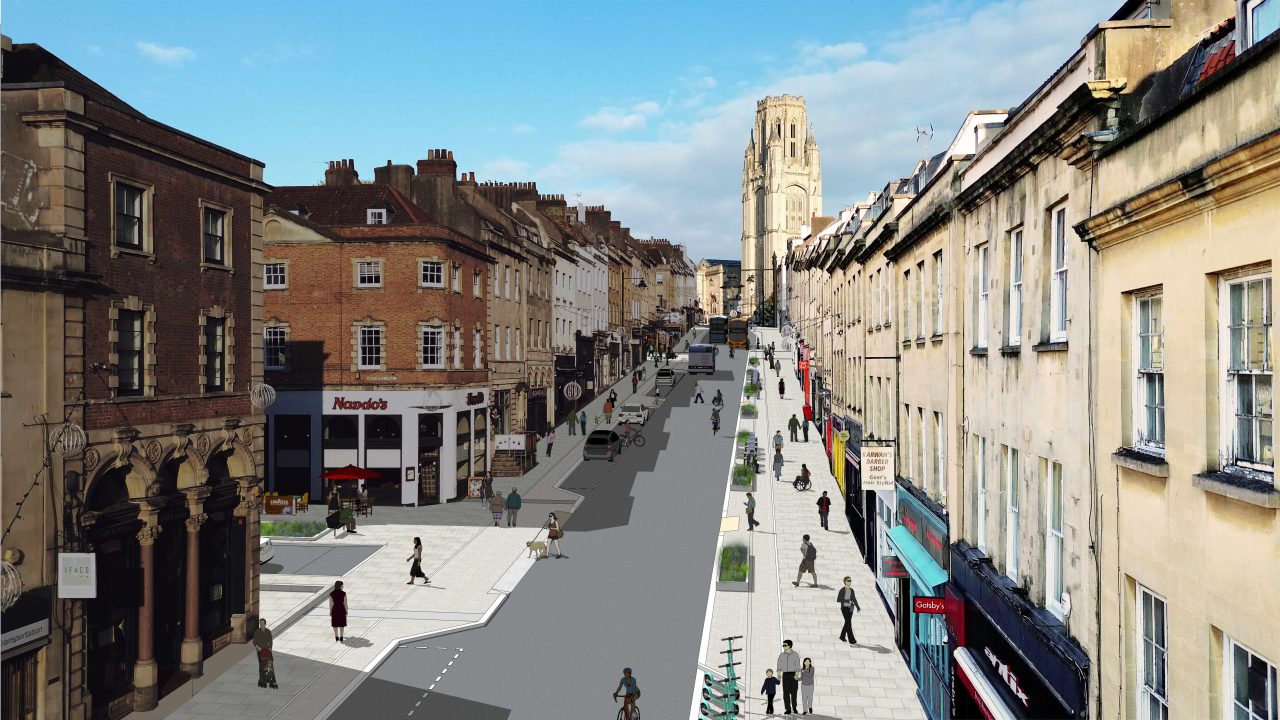
Central section – Victoria Street
Work on Victoria Street began in January 2025 and is expected to be completed by late spring 2026.
The lower section is nearly finished, which includes:
- a two-way separated cycle path
- high quality paving
- expanded public spaces
- a crossing point level with the pavement on Bath Street
- a large bus shelter with a living roof
Local businesses between Temple Street and Church Lane are benefitting from wider pavements allowing space for outdoor seating, with similar improvements planned up to St Thomas Street East.
Progress at the Counterslip junction has been delayed because of scaffolding on the Milliners building. Once this is removed, work is expected to begin in January 2026.
Victoria Street will remain closed to northbound traffic between Temple Gate and Counterslip until the end of the works.
Buses will continue to operate along Victoria Street with the northbound diversion still in place.
Road resurfacing will take place overnight towards the end of the project in late spring 2026.
Our contractor for these works is ETM. If there’s a problem onsite, email ETM on info@ETM-Group.co.uk or phone 0117 953 3654.
Central section – College Green and Canons Road junction
Work to improve the junction began in August 2025 and is expected to be completed by the end of 2025.
It includes:
- replacing the outdated three-way traffic signals, which are hard to maintain and can have problems detecting vehicles, which can lead to traffic building up
- upgrading the pedestrian and cycle crossing, including better facilities for visually impaired pedestrians
- increasing the amount of pedestrian space by removing the left turn slip road out of Canons Road
- improving cycling links between Park Street and the city centre
There are temporary signals in place that are responsive to traffic build ups.
Access for pedestrians and cyclists is being maintained.
Diversions will be needed throughout the works when traffic will either be signposted to go via Anchor Road and Jacobs Wells Road, or via Park Row.
South section
The south section of the route starts from the Three Lamps junction on the A37 and follows Wells Road through Knowle, past Airport Road, onto West Town Lane and into Sturminster Road.
South section – Stockwood
Worrk started in November 2025 to improve active travel routes in Stockwood. It is set to be completed by the end of 2026.
It includes:
- Creating a two-way separated cycle path between West Town Lane, where it meets Hither Bridge, and Sturminster Road, where it meets Manston Close. This will link Whitchurch Way to Route 3 of the National Cycle Network.
- Building a zebra crossing on West Town Lane between its junctions with Imperial Road and Hazelbury Road.
- Refurbishing a bus stop on Sturminster Road – a temporary bus stop will be provided.
- Moving the bus stop by Hither Bath Bridge on West Town Lane further up the road to between its junctions with Beryl Grove and Imperial Road. This will allow the pavement on West Town Lane to be shared by pedestrians and cyclists, allowing for an unbroken cycle route from Hither Bath Bridge across to Sturminster Road.
There will be temporary traffic signals in place throughout the works so expect some delays to your journey.
Access for pedestrians and cyclists will be maintained.
The works will impact the number 2, 2a and the 36 and 515.
A small section of Imperial Road will be closed at its junction with West Town Lane for the contractor’s site compound.
South section – Further works in 2026 and 2027
Work in Stockwood will take place in 2026 and 2027 and will be carried out in phases to limit disruption.
It includes adding:
- Controlled pedestrian crossings at the Wells Road and West Town Lane junction
- New and upgraded crossing infrastructure around Stockwood
- Traffic calming measures
- Inbound and outbound 12-hour bus lanes on Wells Road, running from Whitecross Avenue to the junction of Wells Road and West Town Lane
Events
Below you will find a series of upcoming events
swipe to read more
No results found.
News and updates
swipe to read more

9 January 2026
Bus Route 2
Whiteladies Road project extended into the new year
Construction work, to prevent water from pooling and to improve walking, wheeling and cycling routes on the lower part of Whiteladies Road, has started up again after onsite investigations into underground drainage issues were completed.

Construction Update
Key junction to close overnight in the centre for resurfacing works
Canon’s Road and College Green junction
15 Dec 8pm-5.30am and 16 Dec 11pm-5.30am and 17, 18 & 22 Dec 9pm-5.30am

5 December 2025
Bus Route 2
An update on the Victoria Street improvement works
Major works to enhance Victoria Street’s active travel and public transport routes have reached a significant milestone this week, with over half of the project now complete.
Construction Update
Lower part of Whiteladies Road to close to motor vehicles this December
Whiteladies Road (lower section)
Monday 1 to Friday 12 December 2025
Construction Update
College Green and Canons Road junction works update
College Green, Canons Road, St Augustine’s Parade
24 to 26 November and 1 to 12 December 2025

18 November 2025
Bus Route 2
Bus Route 2 update: Queens Road, the Triangle, Park Street and College Green
In January and February 2025, the council shared updated designs for the central section of the number 2 bus route. This is part of a multi-million pound project to improve the number 2 bus route along the A37 and A4018 from Henbury to Stockwood.

1 October 2025
Bus Route 2
Work to boost active travel in Stockwood to start in November
Construction work, to make it safer to walk, wheel and cycle through Stockwood, is starting in November 2025, as part of the project to improve the number 2 bus route through Bristol.

29 September 2025
Bus Route 2
Investing to improve key city centre junction
Work to improve a key city centre junction will begin on Monday 11 August in a bid to improve journeys for people travelling from the centre towards College Green and Park Street.

30 June 2025
Bus Route 2
Whiteladies Road to close northbound for flood prevention works
Construction work, to prevent flooding and improve walking and cycling routes on a stretch of Whiteladies Road between its junctions with Tyndalls Park Road/St Pauls Road and Queens Road, will start on Monday 14 July 2025.